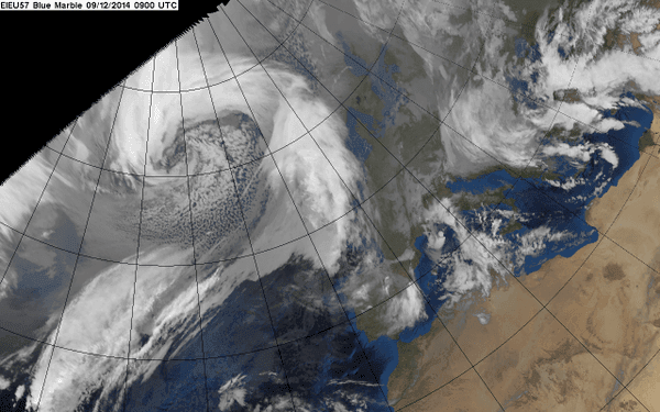
The Met Office has upgraded its weather warnings for gale force winds expected across much of Scotland today.
An Amber (Be Prepared) warning has been issued for severe gales with gusts around 80 mph mainly over the Outer Hebrides and Northern Isles. This could lead to disruption to travel, power and some dangerous waves over the causeways.
Disruption could also be experienced over the rest of the country, including Fife, which is covered by a yellow warning for high winds, with ferries, rail services and bridges likely to be affected.
Transport Scotland is activating the Multi-Agency Response Team (MART) to monitor the conditions. The MART, which involves partner organisations such as Police Scotland and the Met Office, is being co-ordinated at the Traffic Scotland Control Centre in South Queensferry with access to the best technology available to monitor the situation and react accordingly.
Deputy First Minister John Swinney said:
"Having visited Transport Scotland's National Control Centre to receive an update on preparations I am confident we are well placed to cope. However, weather events can cause significant disruption and it's important that the public take heed of the latest travel and safety advice this week.
"Our response to major transport incidents is now better co-ordinated and under one roof with experts working alongside each other.
"We use state of the art monitoring to prepare for all conditions. Weather stations throughout the trunk road network relay information to our operating companies, on temperature, wind speeds and rainfall.
"Before heading out, I would urge the public to consider the conditions. They should listen to radio reports, visit the Traffic Scotland website or twitter feed and take note of the latest police advice.
"The Scottish Government's annual campaign, Ready for Winter, is a good reminder of the simple actions we can all take in an hour to prepare for adverse conditions. Information is available at Readyscotland.org."
Transport Minister Derek Mackay said:
"We know from past experience that winds of this severity can disrupt travel, leading to cancelled ferries, train services and sometimes even closing bridges, or leading to restrictions. The gale force winds will also make high-sided vehicles particularly prone to being blown over and we can expect trees to be at risk also.
"Decisions, by the authorities, to alter services are never taken lightly but safety is paramount.
"A great deal of work has already been undertaken to make sure that Scotland is prepared, however we also need the assistance of the public when it comes to taking on board travel advice, taking appropriate action, and driving to the conditions."
Steve Willington, Chief Meteorologist at the Met Office, said:
"Very strong winds are likely to affect northern and central parts of the UK from early Wednesday and last through until early Thursday as a very deep low pressure system moves slowly eastwards between Scotland and Iceland. A period of severe gales is likely over northern and central Britain, as well as the potential for storm force winds over north western coastal areas of Scotland."
David Dickson, Network Rail route managing director for Scotland, said:
"Safety has to be our first consideration during severe weather and we are withdrawing a limited number of services until the worst of the storms have passed.
"We will be monitoring conditions on the ground closely throughout the night and into the morning and will have teams in place across the country to react quickly to any damage caused by the weather.
"We are working closely with the train operators and other industry partners to do everything we can to reduce disruption, while also operating a safe network for passengers."
Richard Brown, Head of Hydrology for the Scottish Environment Protection Agency (SEPA), said:
"From today, onwards, the risk of coastal flooding is expected to impact on north western coastlines, especially Caithness, Sutherland, the Western Isles and Argyll and Bute, however impacts are likely to also affect the Orkney and Shetland Isles and the entire west coast - including Firth of Clyde, Clyde estuary and Dumfries and Galloway. The potential for strong to gale force winds, very large waves and tidal surges could result in localised flooding to roads, coastal pathways, causeways and individual properties from spray and wave overtopping.
"The Scottish Flood Forecasting Service predicts that flooding is expected to continue throughout the week, with Wednesday forecast to experience the largest waves and greatest impacts due to the strength of tidal surges. There is a risk of significant flood impacts from wave overtopping and spray during this time, before large waves begin to lessen on Thursday.
"We would strongly encourage people to remain vigilant and be mindful of the conditions in their locality and when travelling, especially along more exposed coastal areas. Members of the public can access the latest flood updates for their area via our website, and sign up to the Floodline direct warning service by calling 0345 988 1188."

 10°C
10°C
 10°C
10°C